Overview: The whole Amalfi Coast on foot


Stage | Duration | Increase | Descent | Route | Overnight stay in |
|---|---|---|---|---|---|
| Journey to Salerno | Salerno | ||||
| Stage 1 | 6:00h | 815m | 983m | 11.5 km | Maiori |
| Stage 2 | 3:30h to Amalfi / 4:30h to Pogerola | to Amalfi: 500m to Pogerola: 800m | to Amalfi: 500m to Pogerola: 500m | 7.5 km to Amalfi / 9.7 km to Pogerola | Amalfi or Pogerola |
| Stage 3 | from Amalfi: 4:00h from Pogerola: 4:30h | from Amalfi: 950m from Pogerola: 950m | from Amalfi: 320m from Pogerola: 620m | 10 km | Bomerano |
| Stage 4 | 3:45h | 350m | 840m | 10 km | Positano or Colli S. Pietro |
| Additionally possible: Detour to Monte Vico Alvano | 2:00h | 320m | 320m | 5 km | |
| Stage 5 | 5:00h | 460m | 500m | 12 km | Schiazzano |
| Stage 6 | long version: 5:15h short version: 3:45h | long version: 685m Short version: 445m | long version: 955m short version: 720m | long version: 16 km short version: 12.5 km | Sorrento or alternatively again in Schiazzano |
| Total (longest variant) | 31:00h | 4.380m | 4.718m | 74 km in the longest version |
By the way, we have created a convenient and clear planning aid for planning your trip and booking accommodation: To the planning table.
From Salerno to Sorrento in 6 day stages
Although the Amalfi Coast has been one of Italy's most popular destinations for decades and is also ideal for hiking holidays, most Amalfi holidaymakers with a wanderlust are surprised to find that half-day and day hikes are almost exclusively on the agenda. Multi-day hikes from place to place on the Amalfi Coast? Maybe even the entire coast from Salerno to Sorrento on foot? Even local hiking guides reacted with amazement when we told them about our planned route. But they thought it was a very good idea, just like we did!
What the Amalfi Coast lacks in comparison to other hiking areas is perhaps a real attraction of the calibre of a European long-distance hiking trail. Although the CAI-300, a major hiking trail of the Italian Alpine Club, crosses the entire Amalfi Coast from east to west, the trail is neither particularly well known nor has the official route been chosen in a particularly well thought-out way, as it strays far too far into the hinterland in some places.
From our point of view, we made the best of it: a clever mix of CAI-300 and its byways takes us from Salerno to Sorrento in six day stages - including arrival and departure very well suited for an 8-day holiday!
")
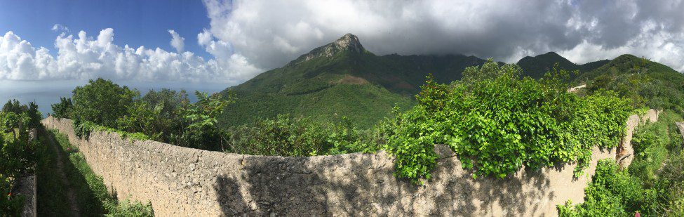
The Amalfi Coast as a hiker's paradise: Idyllic hiking trail just before Bomerano (stage 3)

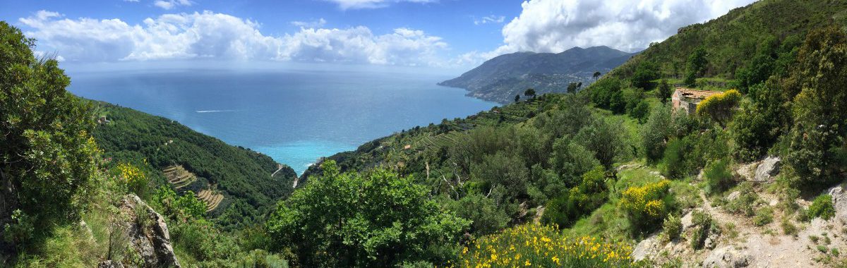
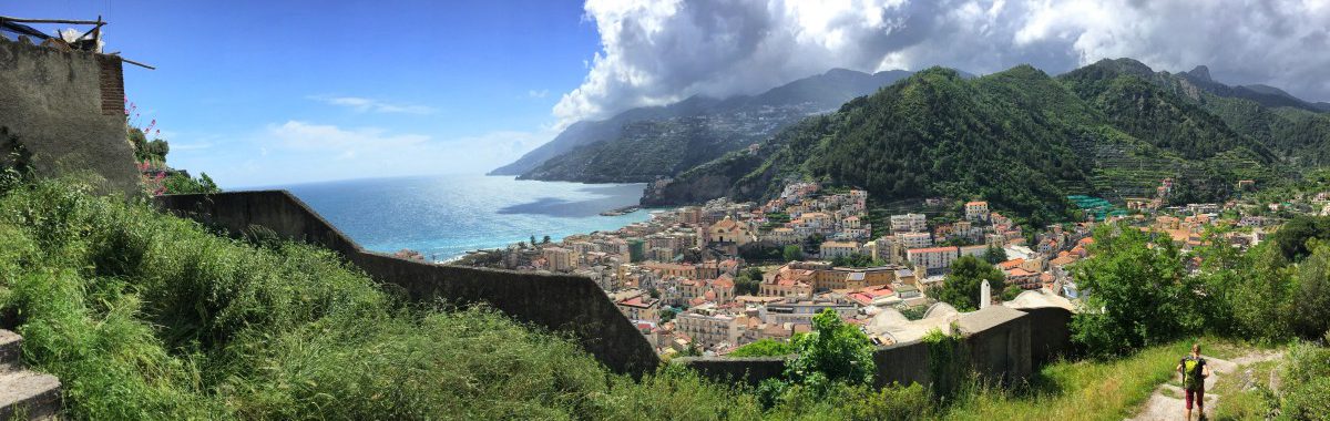
Hiking on the Amalfi Coast is rewarded with many great views. Here: View of Atrani, the immediate neighbour of Amalfi.
The route in brief
On the day of arrival we stay overnight in the pretty and appealing town of Salerno, which can be reached very easily by train from Naples (see Arrival). The start of the hike is a few kilometres or a short bus ride west of Salerno (see Stage 1).
From here on, we continue completely on foot for the next few days. Only at the end of stage 4 do we take the bus again for a short distance from Positano: this is because this part of the coast is very steep and rocky, so there is no really recommendable path leading west from Positano. According to maps, there is supposedly a section of the CAI-300 hiking trail at an altitude of about 800 metres above Positano, but we tried in vain to find this trail for two hours during our hike in May 2016. Therefore: Bus ride from Positano to Colli S. Pietro!
Colli S. Pietro offers a great short hike - as "compensation" for the distance covered by bus - which, depending on your condition and the weather, can be done either directly after stage 4 in the afternoon or in the morning before stage 5 (see Hike to Monte Vico Alvano).
Stage 6 leads with a shorter and a longer variant via Punta Campanella to Sorrento (see Departure).
Shorter variants possible: departure after stage 4, 5 or 6
For all 6 stages, including arrival and departure days, 8 days should be planned. If you have less time, you can shorten the route at the following points:
- Departure after stage 4: the suggested bus from Positano continues to Sorrento via Colli S. Pietro. From there you can reach Naples airport within two hours.
- Departure after stage 4 with morning hike to the "Monte Vico Alvano": After stage 4, stay overnight near the bus stop "Colli S. Pietro", but on the day of departure, take the relatively short hike up the "Monte Vico Alvano" in the morning. Departure: Bus ride from the "Colli S. Pietro" to Sorrento.
- Departure after stage 5: From Schiazzano there are (a few) bus connections to Sorrento, but in any case it is possible to leave for Sorrento by taxi (ask at the hotel or in one of the restaurants).
- Departure with shortened stage 6: The shortest variant of stage 6 is as follows: Schiazzano - Termini - white chapel Chiesa San Costanzo - short stretch on the CAI 300 towards Punta Campanella - back to Termini, from there by bus to Sorrento.
longer variants: Extra tours for connoisseurs
For those who can or would like to take a little more time, the following extensions are available:
- 2 nights in Bomerano: If you spend two nights in a row in Bomerano, you can take an extra tour to one of the peaks of the so-called "Milk Mountains" - in Italian "Monti Lattari" (half-day hike). From an altitude of approx. 1,300 m, you have a wonderful panoramic view of the Gulf of Naples, Mount Vesuvius and the Amalfi Coast in good weather.
- additional days of recreation in Schiazzano: From our point of view, the hotel in Schiazzano recommended by us is well worth a longer stay (Hotel Casa Lubra Relax).
.")
Would you like a little extra tour? Panoramic short hike to Monte Vico Alvano (between stages 4 and 5).
Variant as a hiking holiday with fixed accommodation
Last but not least, it is of course also possible to hike the stages of the long-distance hike in sections as day tours. More information on this at: Variant with fixed accommodation.
3D preview of the long-distance hike
The entire long-distance hike is available in a three-dimensional overview. You can even flexibly change the camera perspective there by dragging and dropping!
Link: sportstracklive.com

Stage 1: Map
From Raito to Maiori
Stage 1: Route description
Bus connection to Raito
The first stage of our Amalfi Trail begins in Raito, a small village a few kilometres west of Salerno, about 150 metres in altitude above the coastal village of "Vietri sul Mare".
There are several bus connections from Salerno to Raito, but usually only one direct connection without changing buses per hour (journey time approx. 15 min). Bus tickets cannot be purchased on the bus itself, but must be bought in advance in one of the numerous "Tabacchi" shops (recognisable by the sign with the big T), a kiosk or a bar. It is therefore advisable to get your bus tickets the evening before at the latest and to find out about the departure times. The departure times can be found, for example, via the following link (starting stop in Salerno on Via Roma, approximately at the level of the cathedral): https://moovitapp.com/. The "Unico Campania" app operated by the transport association also provides information about all departure times and even allows registered users to buy tickets via the app (thanks for this information to Martina!). Download the app at https://www.unicocampania.it/app-unico-campania, the app is also useful for the bus ride at the end of stage 4.
The best bus connection: As of May 2022, bus line 001 runs directly to Raito without changing buses and turns around there (on Sundays and public holidays, this may vary). Other bus connections require a change of buses or a longer walk up to Raito, which lengthens the hike accordingly.
Attention: In Italy, it is customary for passengers to beckon the bus. It is not enough to simply stand at the bus stop at departure time. You should wave at the bus to signal that you want to get on.
Facts about stage 1
Altitude metres: 815 m ascent / 983 m descent
Duration: 6:00h (without breaks)
See also Elevation profile in detail
GPS route download for stage 1
Places to stop between Raito and Maiori
There are no refreshment stops along the way, but there are two small supermarkets in Raito that can provide fresh bread on request.

Shortly above Raito, the beautiful view in the midst of nature begins

The entrance gate of the "Santuario di Maria Santissima Avvocata sopra Maiori" in the fog
Entry point
Our hike begins at the small church of Raito: opposite the church, to the right of the artistically decorated fountain with columns, a staircase leads upwards. The stairway, enclosed by walls, leads us quickly upwards and out of the village. On the left we see the slope that we still have to overcome in the course of the morning. After about 20 minutes, you reach a transversal path (waypoint 1), which you follow to the left into the village of "Albori".
From Albori to the saddle point at Monte Falerio
In Albori, we walk down past the church, left past the turning platform (waypoint 2) onto a path marked red and white (the official path designation of the "Club Alpino Italiano" for this part of the hike is "CAI-303"). About 15 minutes after Albori, we reach a fork in the path at a watering hole (waypoint 3). Here we take the path up to the right.
The trail takes us more or less in a direct line upwards to the saddle point (waypoint 4) next to Monte Falerio (calculated from Raito after about 2 hours).
Via the Cappella Vecchia to the Santuario della Madonna Avvocata
From waypoint 4 we follow the ridge in a north-westerly direction, gaining a few more metres in altitude, until after about an hour we reach Cappella Vecchia at 694 metres above zero. Here we meet the CAI300 trail (waypoint 5) and follow it to the left, always sideways along the slope. At the next ridge at about 900 metres above sea level, the CAI300 branches off to the right into the hinterland, but we keep left towards the coast and about 30 minutes after the Cappella Vecchia we come to the pilgrimage church "Santuario della Madonna Avvocata" (waypoint 6, with full name also "Santuario di Maria Santissima Avvocata sopra Maiori").
From here you have a great view of the coast in good weather - but we were in the clouds or fog during our hike and had a very mystical impression instead.

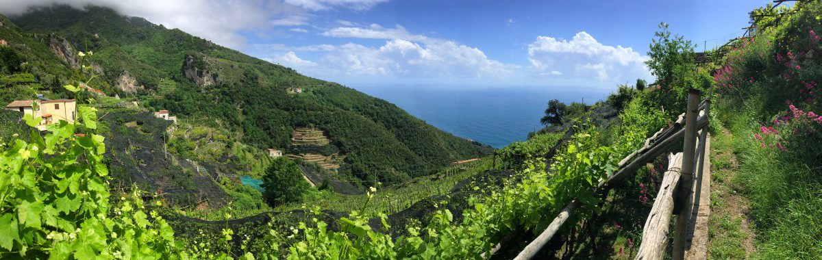
View of the Amalfi Coast on the descent from the Santuario della Madonna Avvocata
Descent to Maiori
To descend, we leave the sanctuary railings through the archway we came through and go around the southern tip of the small plateau. The path leads us down and after a short while meets a cross-cutting path (waypoint 7), which we follow to the right.
As stage 1 continues, we keep going downhill, round another ridge and then look towards Maiori (about 2.5 hours of descent from the sanctuary).