From Bomerano to Positano and by bus on to Colli S. Pietro
Stage 4: Route description
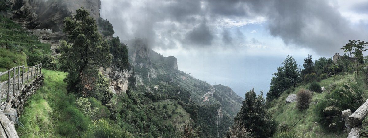 Shortly after the start of the "Sentiero degli Dei", it was unfortunately still slightly cloudy. But the magnificent panorama can already be guessed!
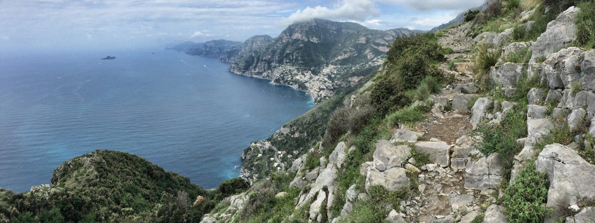
 The Sentiero Degli Dei: View of Positano and the entire Amalfi Coast as far as Capri.
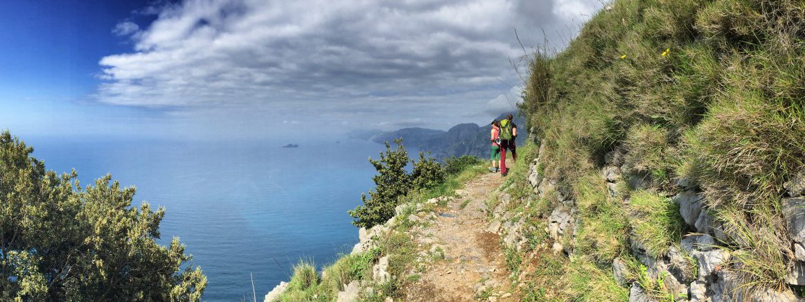 Hiking from Bomerano via Nocelle to Positano - the panorama is a constant companion along the way
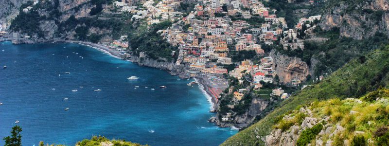 View of Positano from the "Sentiero Degli Dei" - the path of the gods.
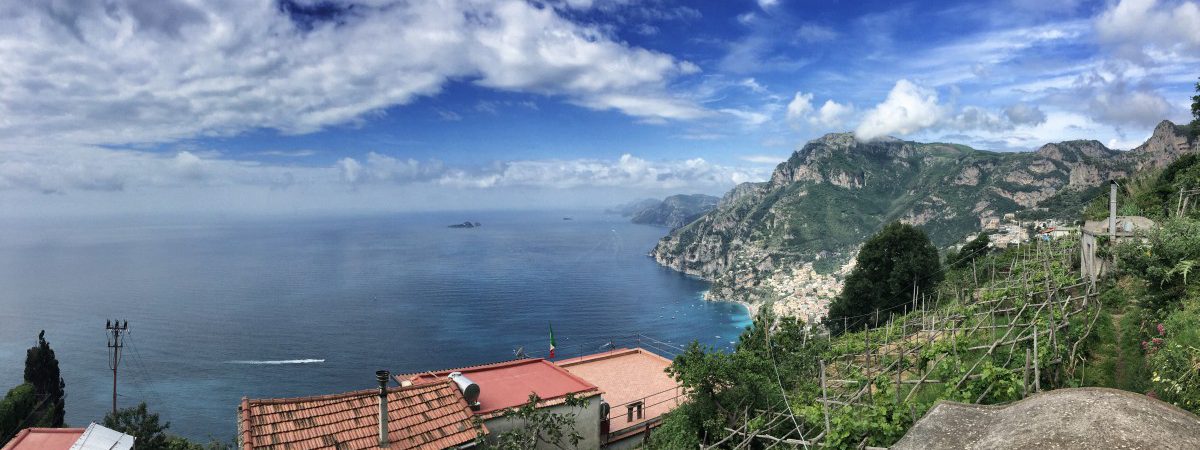 The small square in front of the church of "Nocelle" is a nice place for a break and good for panoramic photos.
The "Path of the Gods" to Positano, bus ride and summit climb
Today we are going to do the most famous part of our hike, the so-called "Sentiero Degli Dei" - in German "Pfad der Götter". A tip on pronunciation: the "gl" in "Degli" is pronounced in Italian similar to the "ll" in Million and not as a German "g". So all in all it's something like this: "Sen-ti-ero De-lli De-i".
The "Sentiero Degli Dei" is very popular because of its spectacular viewpoints and probably also because of its catchy name, and is accordingly well signposted. Getting lost is as good as impossible. However, the path directly on the cliff requires a certain amount of head for heights.
The destination of stage 4 is Positano, a former fishing village that has become world-famous for its spectacular, almost vertically stacked houses. However, the number of visitors and accommodation prices are correspondingly high. For this reason, we describe here a total of three alternatives for stage 4:
normal variant with bus trip the next day: Hike to Positano, relaxed afternoon and evening in Positano, overnight in Positano. To start stage 5, a bus ride to Colli S. Pietro is necessary the next morning.
Variant with bus trip in the afternoon and additional short hike: Since the trail to Positano is more of a half-day hike, this hike can be combined very well with another short hike (Climbing the "Monte Vico Alvano). This requires a short bus ride from Positano in the early afternoon to Colli S. Pietro (the start of stage 5). Details on the bus ride can be found further down in the text. Overnight stays are therefore outside Positano, which is usually rather overpriced.
Panorama variant above Positano without bus ride: The CAI-300 hiking trail runs about 400 metres above the "Sentiero Degli Dei". Instead of descending to Positano, it is possible to return to the higher trail from Montepertuso. This was the option we originally had in mind when planning our tour, but unfortunately we didn't find the way in the rain and fog. In the meantime, however, several other hikers have confirmed to us that this path exists and is very worthwhile (many thanks to Jörg, who provided me with his GPS track for this variant). You can find more details about this variant here: Variant for stage 4.
Facts about stage 4
Altitude metres: 350 m ascent / 840 m descent
Duration: 3:45h (without breaks)
See also Elevation profile in detail
GPS route download for stage 4
A head for heights
Stage 4 may not be suitable for hikers with a fear of heights. See Comment from Flavia.
Refreshment stops
Small snacks in Nocelle, restaurant "La Tagliata" just before Montepertuso, other restaurants in Montepertuso and Positano.

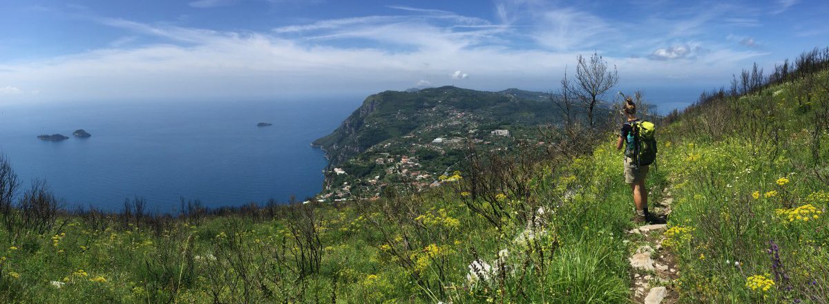
The panorama reaches all the way to Capri: Hiking the "Sentiero Degli Dei" path of the gods
"Sentiero Degli Dei": the path of the gods
The "Sentiero Degli Dei" starts at the main square of Bomerano and leads slightly downhill to "Nocelle" with wonderful viewpoints and great perspectives. The path is particularly impressive in clear weather and with good visibility, when the entire Amalfi Coast stretches out before you to the horizon.
The first part of the hike up to the small church of "Nocelle" leads mostly gently downhill and is therefore very pleasant to hike. The steep part to Positano only follows in the second part. Many hiking groups are therefore picked up again by their coach in Nocelle, but for us it's down many hundreds of steps to Positano.
From Bomerano to Nocelle
Due to the good signposting of the "Sentiero Degli Dei", we will limit ourselves at this point only to the essential turn-offs:
- 200m after leaving the village square of Bomerano, the path passes under a bridge, beyond which we have to turn right (waypoint 1).
- After about 30 minutes, directly after a two-fingered rock on the side of the path, we reach a small hilltop with a ruin and a "T-junction" (waypoint 2): Turn left here and immediately right again to a watering place with beautiful signposting in the direction of "Nocelle / Positano").
- In Nocelle (approx. 1:45 h from Bomerano), keep to the left or downhill until you reach a small church with a viewing platform and public WC (waypoint 3).
From Nocelle to Montepertuso
From Nocelle there are two different ways to get to Positano: either you take the direct way down, which simply continues down from the small square in front of the church of Nocelle, or an alternative way via the village of "Montepertuso". Both variants are beautiful, but the direct path to Positano leads along the busy coastal road SS163 for about 1 km at the end.
We describe here only the variant via Montepertuso, as this is less frequently climbed and requires more explanation than the "direct" variant.
From the church square in Nocelle, go back a little way. A few metres above, a path with signs for "Montepertuso Positano" turns off to the left (waypoint 4). Attention: both the bus and the footpath to Montepertuso are signposted. The footpath first leads along below the road with little traffic and from the next bend on the road towards Montepertuso. After a bend to the right, we come to the popular panoramic restaurant "La Tagliata" past to Monteperuso. There we pass the sports field and after a right turn we reach the triangular village square with some restaurants and a supermarket (waypoint 5, about 40 min from Nocelle to Montepertuso).

Fountain with signpost on the Sentiero Degli Dei

On the "Sentiero degli Dei" you walk between the sky and the sea

Nocelle with its small church tower is the intermediate destination on the "Sentiero Degli Dei".

View above the restaurant La Tagliata: View towards Positano
From Montepertuso down to Positano
About 350m after the village square of Montepertuso, directly in front of house no. 10 and recognisable by the crossing zebra crossing, the steep path to Positano branches off to the left (waypoint 6). A few metres after entering the stairway, an even steeper path branches off to the left. It doesn't really matter which of the two stairs we follow, as both paths meet again at waypoint 7. In our opinion, however, the left (i.e. steeper) stairway path has the more beautiful view.
At waypoint 7 we meet the SS163 - the "Strada Statale Amalfitana". Here is the first SITA bus stop from which we could go towards Sorrento or Colli San Pietro. The buses usually run every half hour, but tickets must be purchased in a tabacchi shop before starting the journey (alternatively via the "UnicoCampania" app, see note on stage 1). Attention: The buses are sometimes overcrowded, even in low season, so that you may be turned away by the bus driver and have to wait for the next bus. It is therefore advisable to plan a little more time. A current bus timetable can be downloaded here: www.sitasudtrasporti.it (As of January 2019, bus number 5070 is relevant between Positano and Sorrento).
Somewhat more convenient and interactive is the timetable prepared by a third-party provider, which can be accessed via the following link: moovitapp.com. This international public transport guide shows not only the departure times but also the route of the bus line including all intermediate stops. In Positano, all SITA stops are on the SS163. This also applies to today's destination: the SITA stop at the Bar Internazionale (Tabacchi shop diagonally opposite).
Before that, however, it's downhill again: further, partly somewhat hidden stairways lead us down to the church of Santa Maria Assunta with its striking dome and to the beach of Positano. Note: if you don't find the entrance to the stairs straight away, you should orientate yourself by the zebra crossings - these are usually placed exactly where a stairway crosses the road!
A short summit climb as an afternoon programme?
For those who come back well-fed from lunch after the strenuous descent to Positano and still feel like a short climb to the summit, we recommend the following short hike in the afternoon: Hike to Monte Vico Alvano.
Variant to stage 4: Panorama trail above Positano
As already mentioned above, there is also an alternative for stage 4 that does not require a bus ride at all. Stage 4 is therefore extended by about 3 hours and requires about 600 additional meters of ascent (+500 meters of descent). This variant is 18 km long and is suitable for sporty hikers who can do without a visit to Positano and would rather switch to a secluded panoramic hike above Positano after the often crowded Sentiero Degli Dei. Alternatively, an overnight stay halfway is also possible (e.g. in the Agriturismo La Ginestra, see Field report from Maren).
Until shortly before Montepertuso (see Waypoint 5) The long panoramic variant is identical to the "normal" stage 4, then the paths separate. The turnoff to the higher CAI-300 hiking trail is located approximately at the height of the center line of the Montepertuso football field: here a staircase branches off to the right, which initially leads to the "Rifugio Forestale" mountain hut (ascent approx. 400 meters in altitude), where we meet the CAI-300 again.
Then the route goes more or less flat for a few kilometres in a large arc around Positano. However, before the highest point of the hike, the "Monte Commune", there is another climb of about 200 metres in altitude.
Almost at the end of the hike, shortly before Colli S. Pietro - the destination of stage 4 - there is the possibility of a small detour to Monte Vico Alvano. From here on, the hike is identical to the return route of the Short hike to Monte Vico Alvano described here.
Facts about this variant
Altitude metres: 950 m ascent / 1350 m descent
Duration: 6:30h (without breaks)
See also Elevation profile in detail
GPS route download for stage 4 (long variant above Positano)
Stage 4: Overnight stay
Spoilt for choice: expensive hotels in Positano or a cheap alternative near Colli San Pietro?
Stage 4 ends in Positano - one of the tourist hotspots of the Amalfi Coast. For today's overnight stay we have to decide: do we stay overnight in Positano and accept the higher prices there? Or do we continue with the SITA bus in the afternoon to "Colli San Pietro", from where stage 5 starts the next day and where the accommodation prices are much cheaper than in Positano?
Finding a good and at the same time affordable accommodation in Positano is very difficult and actually only possible with a lot of advance notice or a lot of luck: For a decent double room, you usually have to pay at least 150€ during the season. Worth a try is the very individual Positano Suite B&B with only one room (double room from 180€, Positano Suite B&B) or the family-run Casa Teresa with a great view over Positano (Casa Teresa).
"Colli San Pietro" is the exact opposite of Positano: the district of "Piano di Sorrento" is a loose collection of houses without a recognisable centre. The biggest highlight is the view of the Gulf of Naples - and of course the proximity to Sorrento as well as the Amalfi Coast. Nevertheless, there is a rich choice of decent to good hotels and guesthouses:
- The Villevieille B&B (top picture) is located directly below the main road, but is still surprisingly quiet, which is due to the fact that the rooms are all on the side of the house facing the valley. The owner is not necessarily very cordial, but the rooms are neat. The breakfast terrace with a view of the Gulf of Naples is great.
- The Antico Casale Russo (second picture) is a great choice in a historical ambience, as long as you don't stay there at the weekend: That's when wedding ceremonies regularly take place.
- Right next to the SITA bus stop is the 3-star Royal Hills Hotel with air-conditioned rooms (Hotel Royal Hills).
Despite the lack of a centre, there are some restaurants in Colli San Pietro, e.g. Ristorante Zio Sam or Ristorante La Rosa (both with pizzeria).
We deliberately chose not to stay overnight in Positano on our hike and instead took the scenic hike up Monte Vico Alvano from Colli San Pietro in the morning before stage 5 (see Hike to Monte Vico Alvano).

Overnight stay in "Colli San Pietro" at "B&B Villevieille": breakfast terrace in the morning sun with a view of the Gulf of Naples

The Antico Casale Russo is primarily designed for wedding celebrations - but it's also a great place to spend the night!
Hike to the "Monte Vico Alvano
Map
Route description: Hike to "Monte Vico Alvano" (detour after stage 4)
 Would you like a little extra tour? Short hike to Monte Vico Alvano
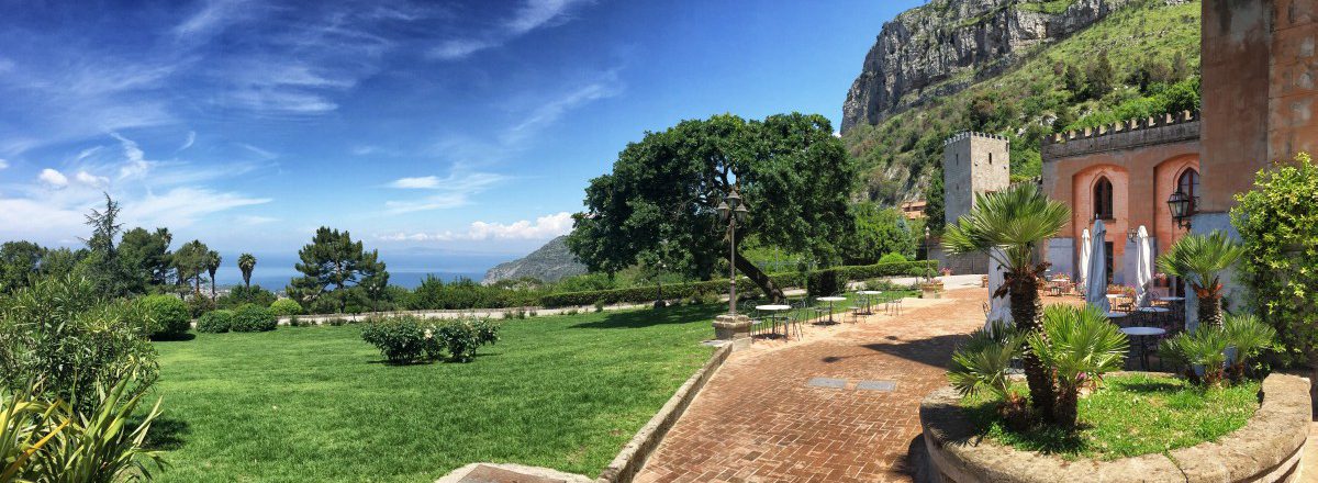 The Castello in the Antico Parco del Principe
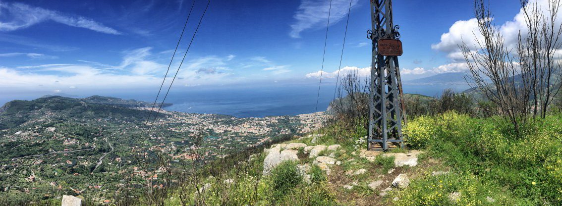 On the summit of Monte Vico Alvano
Through the "Antico Parco del Principe
This approximately two-hour hike can be included as an additional highlight between stages 4 and 5 - either in the afternoon after stage 4 or in the morning before stage 5.
The starting point is the bus stop "Colli San Pietro" at the intersection of the two state roads SS145 and SS163. From here, the destination of the hike - Monte Vico Alvano - is already visible and easily recognisable from the summit cross.
From the bus stop we turn onto Via S. Pietro, which takes us slightly upwards. The path takes us directly to the entrance gate of the park "Antico Parco del Principe" (opening times from 9:00 a.m.), in the middle of which lies the "Castello Colonna", which can be rented for pompous wedding celebrations. The hiking trail leads through the park and past the castle on the right. Behind the castle we tend to keep to the right and thus reach the sunny hiking trail to Monte Vico Alvano.
Reader tip from Julia: Outside the opening hours of the "Antico Parco del Principe" park, the entrance gate can be opened from the inside so that you can leave the park at any time (operated by switch). This is of particular interest to hikers on the long version of stage 4.
View in all directions
The hiking trail leads upwards in several serpentines, the view becomes more and more beautiful and reaches from the Amalfi Coast - clearly visible is the small village "Vettica Maggiore" situated opposite Positano - over the group of islands "Li Galli" to Capri and Sorrento.
At the end of the serpentines we reach a small hilltop, here we turn left and take the "dead end" to Monte Vico Alvano (approx. 1 hour ascent from the start).
Arriving at the iron summit cross, the panorama now grows to almost a 360-degree all-round view. In good weather, the view is magnificent: the Gulf of Naples lies before us, the masses of houses of Naples itself are clearly visible and Vesuvius rises majestically from the plain.
After a sufficiently long photo break, we return along the same path (descent approx. 45 min).

Below us the Antico Parco del Principe and the scattered houses of Colli S. Pietro
GPS route download for the detour to Monte Vico Alvano

Flowers in spring on Monte Vico Alvano - Vesuvius in the background

May is particularly beautiful for hiking - full bloom on the Amalfi Coast
